The Role of UAVs in Modern Surveying
Unmanned aerial vehicles (also known as drones, or by the acronym UAV), have revolutionised modern surveying. In this subject matter expert article by Igne’s Operations Manager, Richard Prescott, discover how your own project’s success can be robustly enabled through the utilisation of Igne’s UAV surveying services.
The adaptability of UAVs, coupled with advanced sensor integration, enhance accuracy, reduce costs, and can improve the efficiency of data acquisition across various surveying techniques. These include photogrammetry, LiDAR, multispectral imaging, bathymetric surveys, thermal imaging, magnetometer, and GPR.
The use of UAVs can also reduce your health and safety risk by eliminating the need for surveyors to traverse rough terrain carrying GPS kits, or accessing confined spaces with a laser scanner mounted to tripod. Instead, UAVs can collect all the necessary data while their operators remain in a safe location.
Integration Today and Advancements Tomorrow
The integration of advanced technologies onto UAV platforms has enabled their versatility. We’ve also seen continued and rapid improvements in sensor accuracy, battery life, flight dynamics, and post-processing software expand UAV capabilities for our clients. Consequently, our UAVs are a critical piece of equipment in our armoury for many of our clients already.
At Igne, we anticipate future developments will include AI-driven data processing and enhanced automation. This might reduce the requirement for a certain amount of human intervention and will certainly increase survey efficiency even further.
Here are just some of the ways we’re already using drones to deliver the survey data our clients rely upon for project success:
UAV Photogrammetry
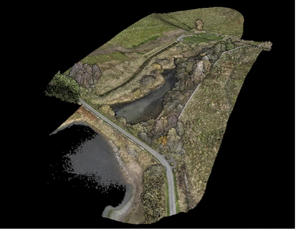
We capture high-resolution images that are stitched into comprehensive 2D maps and 3D models. These models have aided clients in land registry, urban planning, and construction for example.
UAVs can cover vast areas relatively quickly – certainly when compared to alternative surveying methods. And they can capture detailed data that’s inaccessible to traditional survey methods.
LiDAR (Light Detection and Ranging)
LiDAR on UAVs uses lasers to produce highly accurate digital elevation models (DEMs), crucial in forestry management, flood risk assessment, and infrastructure planning.
Unlike photogrammetry, LiDAR can penetrate dense vegetation, providing ground topography data for environmental assessments and habitat studies too.
Multispectral Imaging
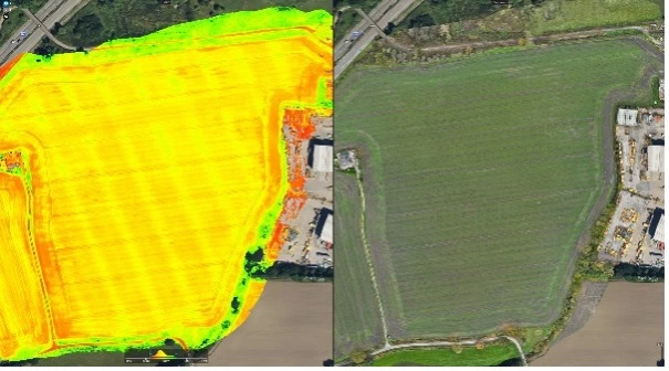
Our UAVs with multispectral cameras capture images in wavelengths beyond visible light. We’ve used this technology to assess vegetation health, to detect pest infestations, identify drainage issues and map invasive plant species.
In agriculture, multispectral imaging enables precise crop monitoring and resource management, optimising fertiliser, herbicide and pesticide application as well as irrigation. In today’s challenging environment were that extra bit of yield can make the difference between profit or loss this technology can only be of benefit, helping to identify issues early, so that control measures can be implemented. It’s a particular area of interest for me, as I have an agricultural background, and I am enjoying working on advancements in this field – excuse the pun.
Multispectral imaging can also be used in heritage and archaeology projects, to locate buried services, and even in UXO detection as it can identify objects hidden below the surface.
Bathymetric Surveys
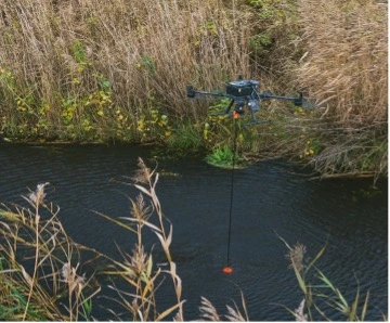
The way we use UAVs to conduct bathymetric surveys is through using sonar or bathymetric LiDAR to map shallow water bodies or coastal areas for example.
Traditional surveying methods struggle in these environments, but UAVs offer a safer and much more cost-effective solution.
They eliminate the need for a surveyor to enter the water or even to launch boats or USVs. We have found our drone services crucial for environmental studies, dredging operations, and flood modelling.
A UAV-mounted GPR can help with the understanding of soft and hard bed detail
Thermal Imaging
UAV-mounted thermal cameras are commonly used to detect heat variations in the prevention of crime, and in emergency response situations. They can provide real-time data for search and rescue operations.
And we have found them to be essential to clients working in infrastructure and who need help with buried services maintenance and to identify heat leaks or electrical faults.
We’ve also been lucky enough to use our UAV-mounted thermal cameras in wildlife conservation; they can monitor species without disturbing habitats.
So, UAVs are transforming the surveying industry by integrating technologies like photogrammetry, LiDAR, multispectral, bathymetric, and thermal imaging. By enhancing precision, reducing risk and costs, and literally opening new horizons in terms of data acquisition and analysis - the future of drones in surveying is undeniable.
As UAV technology and processing software evolve, we’ll ensure we’re at the forefront in terms of utilisation, to drive innovation and success for our clients across sectors including construction, transport, agriculture, and environmental conservation.
If you’d like to discuss how we could utilise UAVs to support your surveying requirements, I’d be delighted to discuss all the options available. Drop me a line: hello@igne.com or call me and my team: 0371 789 1000.
Other articles of interest
Why is UXO still found in Rotherwas, Hereford?
Yesterday, a hand grenade was found in Rotherwas, Hereford. Why is unexploded ordnance (UXO) still found in Rotherwas, Hereford, over 70 years since WWII ended? Learn about Rotherwas' munitions factory, Luftwaffe bombings, and why UXO risk assessments are important for intrusive ground works.
What’s the value of UXO risk mitigation services?
What value do unexploded ordnance (UXO) risk mitigation services bring? What's the potential impact of UXO and who does it affect? Get all the answers to your frequently asked questions here.


